Point Roberts, WA can only ever be reached by land by driving thru BC. I blame KJR John.A piece of Minnesota called "The Northwest Angle" can only be reached by car in summer by going into Canada first.


Colleges
- AAC
- ACC
- Big 12
- Big East
- Big Ten
- Pac-12
- SEC
- Atlantic 10
- Conference USA
- Independents
- Junior College
- Mountain West
- Sun Belt
- MAC
- More
- Navy
- UAB
- Tulsa
- UTSA
- Charlotte
- Florida Atlantic
- Temple
- Rice
- East Carolina
- USF
- SMU
- North Texas
- Tulane
- Memphis
- Miami
- Louisville
- Virginia
- Syracuse
- Wake Forest
- Duke
- Boston College
- Virginia Tech
- Georgia Tech
- Pittsburgh
- North Carolina
- North Carolina State
- Clemson
- Florida State
- Cincinnati
- BYU
- Houston
- Iowa State
- Kansas State
- Kansas
- Texas
- Oklahoma State
- TCU
- Texas Tech
- Baylor
- Oklahoma
- UCF
- West Virginia
- Wisconsin
- Penn State
- Ohio State
- Purdue
- Minnesota
- Iowa
- Nebraska
- Illinois
- Indiana
- Rutgers
- Michigan State
- Maryland
- Michigan
- Northwestern
- Arizona State
- Oregon State
- UCLA
- Colorado
- Stanford
- Oregon
- Arizona
- California
- Washington
- USC
- Utah
- Washington State
- Texas A&M
- Auburn
- Mississippi State
- Kentucky
- South Carolina
- Arkansas
- Florida
- Missouri
- Ole Miss
- Alabama
- LSU
- Georgia
- Vanderbilt
- Tennessee
- Louisiana Tech
- New Mexico State
- Middle Tennessee
- Western Kentucky
- UTEP
- Florida International University
High School
- West
- Midwest
- Northeast
- Southeast
- Other
- Alaska
- Arizona
- California
- Colorado
- Nevada
- New Mexico
- Northern California
- Oregon
- Southern California Preps
- Washington
- Edgy Tim
- Indiana
- Kansas
- Nebraska
- Iowa
- Michigan
- Minnesota
- Missouri
- Oklahoma Varsity
- Texas Basketball
- Texas
- Wisconsin
- Delaware
- Maryland
- New Jersey Basketball
- New Jersey
- New York City Basketball
- Ohio
- Pennsylvania
- Greater Cincinnati
- Virginia
- West Virginia Preps
ADVERTISEMENT
Install the app
How to install the app on iOS
Follow along with the video below to see how to install our site as a web app on your home screen.
Note: This feature may not be available in some browsers.
You are using an out of date browser. It may not display this or other websites correctly.
You should upgrade or use an alternative browser.
You should upgrade or use an alternative browser.
Geographical oddities.......
- Thread starter UK_Dallas
- Start date
Point Roberts, WA can only ever be reached by land by driving thru BC. I blame KJR John.
Used to go to Vancouver all the time for work, and never knew this.
Wouldve driven over there just due to sheer oddity of it.
Skied up at Whistler/Blackcomb once and we had flight back thru Seattle. While driving out of Vancouver, saw sign to Pt. Roberts. Probably 15-20 minutes out of the way both directions plus going thru border control both ways. And it's near-empty in winter. I knew the rest I was with wouldn't care so I didn't say anything.Used to go to Vancouver all the time for work, and never knew this.
Wouldve driven over there just due to sheer oddity of it.
It's a result of the 49th parallel border treaty that gave US all continental land south of it. No one knew at the time that the Pt. Roberts land jutted down below the 49th in the Strait of Georgia. US wouldn't give it - a reasonable thing to do - for fishing and water control rights.
Can't believe I have to explain this on the board. See, when a man and a woman love each other very much....
Or when a man and woman meet in a bar and get drunk ...
If you're in Virginia, to get to Pocahontas, VA you have to travel through West Virginia.
If you're in Russell County, Kentucky, to get to the southwest part of the county where Jabez is, you have to drive through Pulaski.
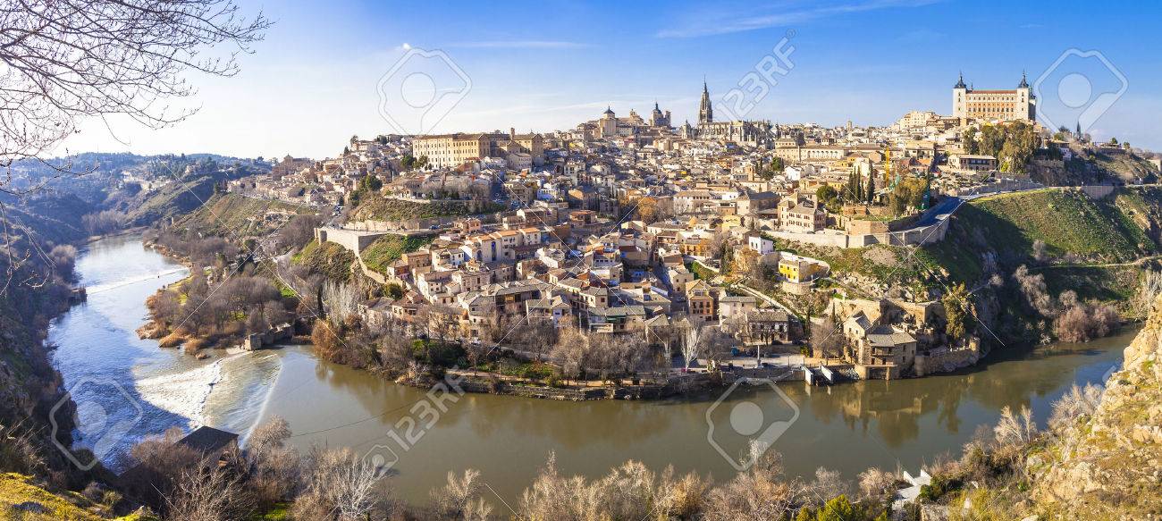
Never been to the Breaks but would like to. Sounds like a beautiful hiking spot.Toledo, Espana
Breaks Interstate Park
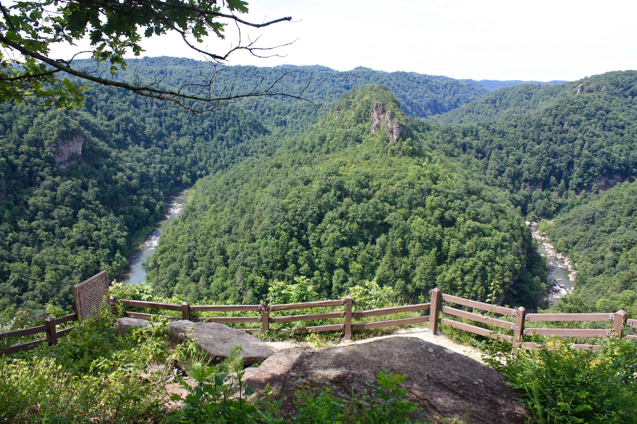
The Breaks is awesome. Been there several times and used to fish nearby John Flannigan lake some.Never been to the Breaks but would like to. Sounds like a beautiful hiking spot.

Concur about it being awesome. Don’t fish so can’t comment there.The Breaks is awesome. Been there several times and used to fish nearby John Flannigan lake some.
It goes right through what was my grandpa's farm he grew up on and he got rock bottom prices for his land when they made 275 especially compared to other farms in the area that currently hold major retail centers on them.I-275 (the real one - OH, KY, IN) is the largest beltway with an Interstate designation in the United States, encompassing an area of over 250,000 acres!
A day with my mother-in-law is also longer than a year.I'll go science on you too. A day is longer than a year on Venus.
A day with my SISTER-in-law is also longer than a year.
Fixed it for you
A day with ANY -in-law is also longer than a year.
Fixed it for you
Polished it up a little more.")
no i see a cowFollow this link and tell me if you don't see the face of a dog or Lion in the land formations.
https://www.google.com/maps/@32.6712861,-109.4222424,60730m/data=!3m1!1e3
Campbell County? My great grandmother (Craig) had to sell her property to the state in Highland Heights.It goes right through what was my grandpa's farm he grew up on and he got rock bottom prices for his land when they made 275 especially compared to other farms in the area that currently hold major retail centers on them.
I've been to one - Toledo - but not the other.Toledo, Espana
Breaks Interstate Park
Not hard to find. It's right next to the Colorado one.The Wyoming panhandle
Can concur. But better than living in Monroe County and having to depend on a ferry to get to your place of business or work. Or living in Cumberland County and working in Monroe County. And I don’t have to commute back and forth, but some people I know do.If you're in Russell County, Kentucky, to get to the southwest part of the county where Jabez is, you have to drive through Pulaski.
Didn't know this existed. Where does the ferry cross what?Can concur. But better than living in Monroe County and having to depend on a ferry to get to your place of business or work. Or living in Cumberland County and working in Monroe County. And I don’t have to commute back and forth, but some people I know do.
Cumberland River well below Burkesville .Monroe County well represented on both sides of the river. It’s a bigger problem for Monroe than Cumberland County. And I’m in Cumberland.Didn't know this existed. Where does the ferry cross what?
Visited both and pretty much in the same spot as the photos.I've been to one - Toledo - but not the other.
Visited both and pretty much in the same spot as the photos.
Doesn’t it ever bother you to sound unintelligent?If you can fake votes, then you can also fake population numbers to manipulate your influence.
![[laughing]](http://l.yimg.com/j/assets/img/emoticons/classic/laugh.r191677.gif "Laughing [laughing]")
I-10 extends from Jacksonville, FL to San Diego, CA, covering roughly 2200 miles. There is more of I-10 in Texas alone than either section east and west of Texas.
Reno, NV is further west than Los Angeles, CA.
Reno, NV is further west than Los Angeles, CA.
I-10 extends from Jacksonville, FL to San Diego, CA, covering roughly 2200 miles. There is more of I-10 in Texas alone than either section east and west of Texas.
Reno, NV is further west than Los Angeles, CA.
I think I knew that about Reno.
No opinion about the other fact, except that you would have to line I-10 with ten dollar bills, and let me pick them up along the way, to get me to drive from Jacksonville to San Diego. What is that, 2500 miles?
Grew up in HH. Mom worked as clerk in old city building on Renshaw. Family kept Joyce Ann Inn in business - and it wasn't dinner. Picked strawberries on Boden Farm where NKU is. Walked down the hill to gravel Blange Road & on to river & old Coney Island ferries.Campbell County? My great grandmother (Craig) had to sell her property to the state in Highland Heights.
BTW, Campbell County itself is an oddity in that it's surrounded by water on all sides except the short south border to Falmouth.
It's a long way, for sure. I'd have to have a lot of time to do so. Having driven across a bunch of I-10, there are certainly long stretches of absolutely nothing along the way. Once you get west of San Antonio there is a lot of brown dirt for 500 miles and El Paso. New Mexico? A whole lotta nothing. A lot of AZ, bout the same. Once you get to CA, it improves.I think I knew that about Reno.
No opinion about the other fact, except that you would have to line I-10 with ten dollar bills, and let me pick them up along the way, to get me to drive from Jacksonville to San Diego. What is that, 2500 miles?
She and my great grandpa had property on 3 Mile Rd which was cut in half by I-275 and I-471. She was born a Stanley from the mountains of Pike County via Clintwood, VA. There were 2 houses, a small trailer, no indoor plumbing just south of Ft. Thomas and 5 miles from downtown. Some of my earliest memories were family shopping at either Albers in Ft. Thomas or Bluegrass Carry Out in HH.Grew up in HH. Mom worked as clerk in old city building on Renshaw. Family kept Joyce Ann Inn in business - and it wasn't dinner. Picked strawberries on Boden Farm where NKU is. Walked down the hill to gravel Blange Road & on to river & old Coney Island ferries.
BTW, Campbell County itself is an oddity in that it's surrounded by water on all sides except the short south border to Falmouth.
Ummm, he clearly stated "roughly 2200 miles".I think I knew that about Reno.
No opinion about the other fact, except that you would have to line I-10 with ten dollar bills, and let me pick them up along the way, to get me to drive from Jacksonville to San Diego. What is that, 2500 miles?
She and my great grandpa had property on 3 Mile Rd which was cut in half by I-275 and I-471. She was born a Stanley from the mountains of Pike County via Clintwood, VA. There were 2 houses, a small trailer, no indoor plumbing just south of Ft. Thomas and 5 miles from downtown. Some of my earliest memories were family shopping at either Albers in Ft. Thomas or Bluegrass Carry Out in HH.
Been to Clintwood many a time.
Was in that Albers - by old Hiland Theater - many a time. Grandparents literally buried about a 100 yards from 3 Mile in St. Stephen's. Don't know your family's names.She and my great grandpa had property on 3 Mile Rd which was cut in half by I-275 and I-471. She was born a Stanley from the mountains of Pike County via Clintwood, VA. There were 2 houses, a small trailer, no indoor plumbing just south of Ft. Thomas and 5 miles from downtown. Some of my earliest memories were family shopping at either Albers in Ft. Thomas or Bluegrass Carry Out in HH.
Alaska is the northernmost state. It is also the westernmost AND easternmost state as part of it crosses Intl Date line and is, therefore, considered east.
AND easternmost
Did something change?
The international dateline also marks the border between Russia and the United States off Alaska's west coast. The islands of Big Diomede in Russia and Little Diomede in the United States are separated by 2.4 miles (3.8 kilometers) of water, with the international date line running midway between them.Jul 18, 2017
Sorry. Most maps define the hemispheres as split at the Prime Meridian and the 180th. There is a part of Alaska that lies across the 180th and is therefore, technically, in the Eastern Hemisphere. So, there is a small part of Alaska that is so far west, it's actually east.
The International Date Line curves around parts of Alaska to avoid one part in one day and other parts in the next day.
My bad - got the Dateline and 180th meridian mixed up.
Similar threads
- Replies
- 95
- Views
- 7K
- Replies
- 36
- Views
- 2K
- Replies
- 136
- Views
- 3K
- Replies
- 0
- Views
- 262
- Replies
- 87
- Views
- 4K
ADVERTISEMENT
ADVERTISEMENT